Tide Charts
- 3.6
- Rating
- 5.00M
- Installs
- Free
- Price

 Analysis by App-foxy
Planning anything around the coast often begins with the same small nuisance: checking the tide. A general weather app may show rain, wind, and temperature beautifully, yet leave you searching elsewhere for high and low water times. That extra step is easy to underestimate until you are trying to choose a launch time, reach a beach before the water covers a path, or organize a short fishing trip. Tide Charts is built around removing that recurring interruption.
I found its appeal less in visual spectacle and more in focus. This is a weather app from 7th Gear that concentrates on ocean tides and nearby conditions rather than trying to become an all-purpose forecast dashboard. The useful promise is simple: once the relevant location is set up, tide predictions remain available without an internet connection. For anyone who regularly visits the same shoreline, that offline angle can save both time and frustration.
The app is free to start, with in-app purchases priced at $1.99 per item. It is rated for Everyone, runs on Android from version 5.0 onward, and its current version is 2.44. Those details make it accessible to people using older phones as well as newer devices. With over a million installs, it is also clearly aimed at a broad audience rather than a narrow professional marine market.
You May Also Like

 Blood Strike: 2.5 Anniversary
Blood Strike’s Loadouts Turn Every Drop Into a Tactical Gamble
A close look at Blood Strike’s custom loadouts: how fast access to signature weapons reshapes its battle royale rhythm, rewards preparation, and narrows the gap between fights.

 Pandora - Music & Podcasts
Pandora’s Music Is Easy to Start, but Harder to Recover
Pandora’s strength is its low-effort path from a seed to a station. Its weak spot is how much confidence it asks you to place in connection, setup, and quiet recovery.

 8 Ball Pool
 Is Built on Rivalries, Rematches, and Routine
A close look at the rivalries, rematches, shared routines, and unanswered safety questions that turn a quick pool match into a persistent mobile community.

 Samsung Music
’s Quiet Strength Is Playing What You Already Own
Its reach comes less from spectacle than from dependable access to a personal library. That simplicity is both the app’s strongest retention engine and its ceiling.

 AccuWeather: Weather Radar
AccuWeather Review: A Quick, Clear Forecast for Everyday Decisions
For everyday plans, the best forecast is the one you can understand quickly. AccuWeather makes rain timing, radar, and local conditions easy to act on, with a few trade-offs.

 Hill Climb Racing
Why Hill Climb Racing Still Turns Crashes Into One More Run
A tiny car, a bumpy hill and one more upgrade: Hill Climb Racing keeps resurfacing because its simple chaos makes every near-miss feel personal.
More From Our News Desk



Making tide planning quicker in real situations
I find tide planning quickest when I treat the app as a preparation tool, not a last-minute safety check. Before heading out, I would confirm the location while connected and note both the arrival window and the time I expect to return; that simple habit makes the prediction more useful than checking only for high or low water.
The first useful setup is choosing the right place
The most important part of using Tide Charts is not learning a complicated interface; it is making sure the selected coastal location matches where you actually plan to be. Tide times are location-dependent, so a nearby station is not automatically interchangeable with the beach, harbor, inlet, or river mouth you have in mind. I would treat the first setup as a practical check rather than something to rush through.
Once the location is selected, the app becomes much more useful as a repeat tool. Instead of opening a broad weather service, navigating through maps, and then looking for a tide section, I can go directly to the information that determines whether a coastal plan is sensible. That narrower workflow is the main reason to keep this app installed: it turns a recurring search into a quick habit.
A good routine is to check the chosen location before saving a plan for the day. Look at the sequence of rising and falling water, then compare it with the time you expect to arrive and leave. This is more helpful than checking only whether the tide is “high” or “low,” because the transition itself can affect access to a beach, the depth at a launch point, or the appearance of a tidal flat.
The offline capability is especially valuable during preparation. I can check predictions before leaving home and still refer to them when reception becomes unreliable near cliffs, remote beaches, or busy waterfronts. It also avoids making the tide lookup depend on a fresh connection at exactly the moment I need it. That does not make the rest of a trip offline, but it does remove one common point of failure.
A simple daily workflow for coastal plans
My preferred workflow is to check the tide before checking the rest of the forecast. First, I decide what the activity requires: exposed sand, enough water for a small boat, access to a rock pool, or a comfortable return route. Then I use the tide information to identify a workable window. Only after that do I consider rain, wind, temperature, and travel time in a separate weather tool if necessary.
This order matters because tide times are not just another weather detail. A pleasant forecast does not help if a route disappears under water before the return journey. Conversely, a low tide may be ideal for exploring a shoreline but unhelpful for launching or swimming. Tide Charts is at its best when it is used as the first planning filter, not as a replacement for every other source of outdoor information.
For a family beach visit, I would check the expected water level around arrival and departure, then leave enough margin for delays. That extra margin is a useful habit because children, parking, crowded paths, and changing plans rarely follow a perfect timetable. The app can make the initial decision faster, but it cannot remove the need for sensible judgment at the shore.
For shore fishing, the benefit is different. Instead of opening a full marine forecast every time, I can quickly inspect the tide pattern and decide whether the timing is worth the trip. A person who fishes the same stretch repeatedly may find this especially convenient because the app keeps the focus on the local rhythm that matters most to that activity.
Where the offline design saves the most effort
The strongest practical advantage is the separation between prediction access and internet access. Many people assume a weather app must constantly refresh to be useful, but tide planning is often done in advance. If I check the relevant information while connected, I can later consult the predictions without repeating the search on location. That is a small design choice with a noticeable effect on preparation.
It also makes the app suitable for a phone that is used as a backup rather than a primary navigation device. I can keep the tide reference available even when I am trying to conserve battery or avoid depending on weak coastal reception. The trade-off is that offline convenience should not be confused with live updates. A stored prediction is useful for planning, but it is not a substitute for checking current conditions when safety depends on wind, waves, storms, or local warnings.
Another less obvious benefit is mental simplicity. A large weather application may offer layers of charts, alerts, radar, and hourly details. Those tools are valuable, but they can also slow down a basic question: when will the water be higher or lower at this place? Tide Charts reduces that decision to a smaller task. For repeat users, less information can be more useful when the goal is simply to establish a workable time window.
How it compares with ordinary weather apps
General weather apps are usually better for atmospheric conditions. They are the natural choice when I need precipitation timing, temperature changes, wind direction, or storm tracking. Tide Charts should not be judged as though it were trying to replace those services. Its value comes from giving tide information a dedicated place in the routine.
There is also a difference between a general coastal forecast and a tide-focused utility. A broad app may include tide information as one small panel among many, which means finding it can take several taps. Tide Charts is more direct for someone whose first question is about water movement. That makes it a better companion for beach access, shoreline walking, fishing, and small-boat planning than an ordinary weather app alone.
On the other hand, someone who visits the coast only occasionally may not want a separate app. If tide checking is a rare need, a familiar weather service or a browser search may feel sufficient. The dedicated approach becomes worthwhile when the same question comes up repeatedly, especially when the answer needs to remain available away from reliable connectivity.
Small habits that make the information more useful
I would avoid treating a single tide time as a hard appointment. A high-water or low-water point is part of a changing cycle, not a guarantee that conditions will be identical at every nearby shoreline. Local shape, weather, wind, and access restrictions can alter what the water feels like on the ground. The app helps establish timing, while observation and local knowledge fill in the practical details.
It is also smart to check the return journey, not just the start. A route that is open when I arrive may be awkward or unsafe later. This is one of the most useful ways to apply the app: use the prediction twice, once for arrival and again for departure. That simple comparison can prevent a pleasant walk from turning into a rushed retreat.
For photographers and shoreline explorers, the tide can define the subject more than the weather does. Lower water may reveal textures, pools, or passages that are hidden later, while a higher tide can change the character of a harbor or beach. Tide Charts is useful here because it supports planning around a natural cycle rather than leaving the timing to chance.
What creates friction during use
The focused design also means I need to be deliberate about what the app is for. It is not a complete trip planner, navigation system, or safety service. I would still use another source for severe-weather information and would not rely on tide predictions alone for boating decisions. The app removes the friction of finding tide timing; it does not remove the responsibility of understanding the environment.
Location selection deserves care because “near you” is not always the same as “the exact place you will stand.” A coastal area can include several beaches, channels, and harbors with meaningful differences. If I were using the app for a new destination, I would verify the selected location before building a schedule around it. This is a more important step than the simplicity of the interface might suggest.
The free entry point is helpful, but the presence of $1.99 in-app items means some users may need to decide whether the basic experience covers their needs before spending anything. I would not purchase an item merely because I use the app occasionally. For frequent coastal users, a small optional cost may be reasonable if it improves the particular workflow they rely on, but the decision should follow actual use rather than assumption.
The age rating of Everyone is appropriate for a straightforward tide reference, although younger users should still receive adult guidance about coastal hazards. A simple interface can make information approachable, but it cannot teach a child how quickly conditions change around rocks, mud, currents, or isolated paths. That distinction matters when the app is used for family outings.
Who should install it and who should skip it
I would recommend Tide Charts to people who repeatedly plan around the shoreline and want a quick, dedicated reference. It makes the most sense for regular beach visitors, shore anglers, walkers who use tidal routes, photographers timing low-water scenes, and anyone who visits places where mobile reception is inconsistent. The offline predictions are the feature that changes it from a basic lookup tool into something worth keeping ready.
I would be more cautious recommending it to someone who wants one app to handle every part of a marine outing. If wind, wave height, storm warnings, navigation, or detailed marine conditions are central to the decision, a broader specialist service will be more appropriate. Tide Charts can sit beside those tools, but it should not be mistaken for the whole safety picture.
Its audience is also narrower than that of a standard weather app. If I only need tomorrow’s temperature and rain chance, this app adds another step rather than removing one. Its value appears when tide timing is the recurring problem. In that situation, the focused approach is not a limitation; it is the reason the app feels efficient.
My final view after using it as a repeat utility
The best thing about Tide Charts is the time it saves on a question that people often have to answer again and again. It does not try to overwhelm me with a complete weather center. Instead, it gives tide planning a dedicated workflow and keeps predictions available when an internet connection is inconvenient. That combination is practical, particularly for familiar coastal locations and outdoor plans that depend on arriving during the right part of the cycle.
The app is not a replacement for a full weather forecast, local guidance, or careful coastal judgment. Its location choice must be checked, its predictions should be used with sensible margins, and offline access should not be confused with live safety updates. Those are important boundaries, but they do not undermine its main purpose.
With a 3.8 average from around eighteen thousand ratings and more than a million installs, it has clearly found a substantial audience, while the 380 written reviews suggest that people have had plenty to say about the experience. I see it as a useful specialist companion rather than an all-in-one weather solution. If tides regularly shape your plans, Tide Charts is a sensible free starting point from 7th Gear. If they rarely enter your decisions, a general weather app may be enough.
My recommendation is to install it before the next coastal outing, set up the location carefully, and test the offline reference while still connected. That quick preparation tells you whether it fits your routine. For me, the app earns its place by removing repeated searching and making the first stage of coastal planning noticeably less awkward.
FAQs for Tide Charts
01What features does Tide Charts offer?
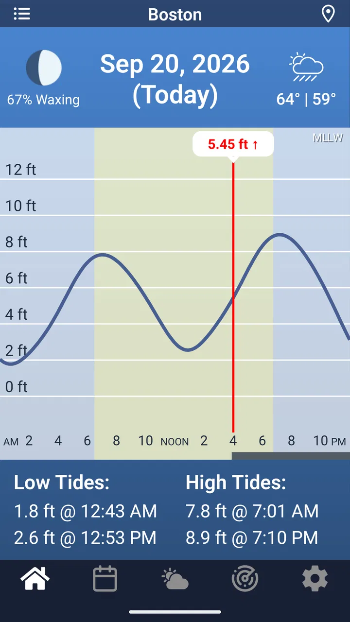
Tide Charts provides users with detailed tidal information including high and low tide times, tidal heights, and sunrise/sunset data. It covers a wide range of locations worldwide and offers interactive tide graphs. The app is user-friendly, allowing for easy navigation and personalized location settings to ensure accurate tidal data.
02Is Tide Charts available offline?
Yes, Tide Charts offers offline functionality, allowing users to access tidal data without an internet connection. This feature is especially useful for users in remote areas or out at sea. However, initial data download requires an internet connection to ensure the app retrieves the latest information.
03How accurate is the tidal data provided by Tide Charts?
Tide Charts uses data from reliable sources to ensure accuracy. It provides real-time updates and detailed predictions, making it a reliable tool for boaters, fishermen, and beachgoers. While it is highly accurate, users should also consider local weather conditions that might affect tidal behavior.
04Is Tide Charts free to use, or does it have a paid version?
Tide Charts is free to download with access to basic features. It also offers a premium version with additional features such as personalized alerts, ad-free experience, and extended location coverage. Users can choose to upgrade for enhanced functionality based on their needs.
05Can I customize the locations in Tide Charts?
Yes, Tide Charts allows users to customize and save multiple favorite locations. This feature is convenient for users who frequent different coastal areas. By setting preferred locations, the app provides quick access to tidal data without the need to search each time, ensuring a personalized experience.
Pros
- User-friendly interface for easy navigation.
- Real-time tidal data for accuracy.
- Offline access to saved locations.
- Customizable alerts for tide changes.
- Supports multiple locations worldwide.
Cons
- Limited to tidal data only.
- Ads can be intrusive at times.
- Requires GPS for best accuracy.
- No interactive maps available.
- Limited customization for alerts.

Tide Charts
Gallery